
Welsh Government Contract for Common Land Digitisation
The parent company of gi Perspective, Lovell Johns, is delighted to be supporting specialist software ...
The parent company of gi Perspective, Lovell Johns, is delighted to be supporting specialist software ...
You may remember that we developed and maintain the EMODnet Human activities web portal which presents marine ...

With an ever-increasing demand for our Geographic Information Systems and Solutions, Lovell Johns has launched a new brand and ...
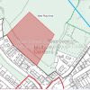
As experts in cartographic production, we’ve continuously provided printed proposals maps to local authorities for well over 25 years. Printed ...
gi Perspective provides organisations of all shapes and sizes with geographic information and digital mapping solutions, utilising our staff's breadth of experience to exceed customer expectations.