Planvu Policy Mapping for Local Government
gi Perspective provide planvu online mapping for many local authorities in England and Scotland, working with this client base since 2005.
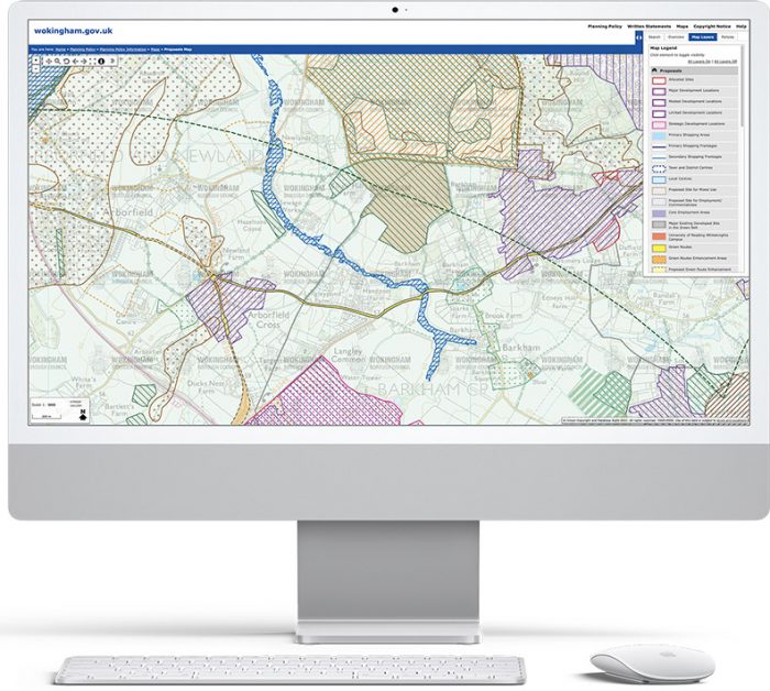
What is planvu?
The large interactive map display allows the user to easily search, move around and zoom in to specific Local Plan policies and associated textual information.
How is planvu configured and provided?
- We take GIS data and policy designations information from the local authority at project inception.
- We process the Ordnance Survey base mapping including MasterMap Topography Layer or use Ordnance Survey Premium Maps API through your existing PSGA.
- We configure the local gazetteer for address searching.
- We process the textual information (Written Statement) and create all links to the map.
- We build, test, host and support the software in matter of weeks.
- planvu is built on OpenSource software and is accessed through a web browser.
Book a Demo
Schedule a demo with one of our experts to see our GIS mapping software solutions in action.
Book DemoWhat are the benefits of planvu?
- Easy to update as a Local Plan develops through stages and grows
- Requires minimal call on local authority resource both at set-up and ongoing
- Matches pre-existing Policy layer styles
- Provides digital engagement with citizens
- Used internally by Planning staff as well as developer and public
- Light-weight and easy to use
- Links to multiple texts
- Links to third-party consultation software
- Tablet and mobile compatible
- Web accessibility friendly
- Reduces printing costs
Planvu Policy Mapping for Local Government
Want to know more about Planvu Policy Mapping for Local Government and how we can help you? Why not chat to a member of our team today by calling 01993 880944 or email us at enquiries@giperspective.co.uk
Experts in Geographic Information Systems
gi Perspective provides organisations of all shapes and sizes with geographic information and digital mapping solutions, utilising our staff's breadth of experience to exceed customer expectations.
See our GIS Services