5 things you can do with Planvu in 2 minutes
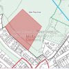
As experts in cartographic production, we’ve continuously provided printed proposals maps to local authorities for well over 25 years. Printed ...
As experts in cartographic production, we’ve continuously provided printed proposals maps to local authorities for well over 25 years. Printed ...

We look at five sectors that are increasingly using drones for survey and mapping purposes
Drones have been in the ...
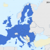
The European Union has not always consisted of the 28 member states that you find today
As Brexit is now ...
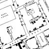
Visualising historic map data in a modern Geographic Information System (GIS) setting
It goes without saying that with a rise ...
gi Perspective provides organisations of all shapes and sizes with geographic information and digital mapping solutions, utilising our staff's breadth of experience to exceed customer expectations.