We’ve been leading providers of Local Authority Proposals or Policies Map solutions in print and online for over 20 years. As you might expect, we’ve needed to adapt how our solutions keep pace with changing legislation and appetite for dynamic plan publication.
Going as far back as 2004 with the introduction of the Local Development Framework under the Planning and Compulsory Act 2004, our parent company Lovell Johns launched their first planvu software, in recognition of increasing demand for a more dynamic mapping solution.
We then quickly managed to integrate with providers of e-consultation software in order to provide a seamless transition between local planning consultations and the latest Ordnance Survey mapping and proposed policies.
Understanding Neighbourhood Plans
The neighbourhood planning system was introduced by the Localism Act of 2011, but it has taken several years for Neighbourhood Plans to come to fruition. Neighbourhood planning is an optional route for motivated citizens at local authority to influence development of new housing, shops and infrastructure, giving them a set of tools to shape and influence the types of development in their area.
From a slow start, the first adoption was by Cumbria authority Eden in 2013, there are now many hundreds of Neighbourhood Plans or Neighbourhood Development Plans (NDPs) developed and adopted across the country.
We love when a planvu comes together!
gi Perspective now has several clients using planvu online mapping to publish Neighbourhood Plans, as it is quick and easy for our software developers to take the limited set of GIS layers and publish in the open source software. Several councils have taken advantage of planvu’s adaptability by bolting on Neighbourhood Plans to existing adopted Local Plan mapping.
For example, Dorset Council have now published as many as 10 Neighbourhood Plans for West Dorset, Weymouth and Portland, starting with Cerne Valley which was made in 2015 and 3 further plans in July 2020 for the Bridport Area, Upper Marshwood Vale and Sutton Poyntz.
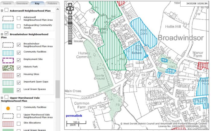
Dorset Council have added their plans to the existing user interface as an extension to the Key, making it easy for the reader to interrogate the Neighbourhood Plan policies, in isolation from the Local Plan. Have a look at the Broadwindsor Neighbourhood Plan in Fig. 1 above and on their planvu site.
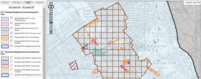
Mole Valley District Council in Surrey have 4 NDPs for Ashtead, Bookham, Capel Parish (including Beare Green and Coldharbour) and Westcott and will also feature one for Ockley Parish once adopted. They made their NDPs in 2017 and provide entry to these plans through a separate Map as seen in Fig.2 below and on their planvu site as well.
Three Rivers District Council have a single Neighbourhood Plan for Croxley Green, made in January 2019 which now forms part of the Development Plan for the borough which can be seen.
In summary, planvu has been (and continues to be) successfully used as a digital tool to assist with citizen engagement at a local level. By taking a discreet set of policy layers and linking these to the relevant Neighbourhood Plan document, we are able to utilise existing software solutions in a cost-effective and quick manner.
Comments are closed here.