How GIS Is Helping Tackle Wildfire Risk in South Wales
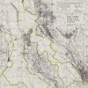
Wildfires might not be the first thing people associate with the Welsh Valleys, but in recent years, they have become ...
Wildfires might not be the first thing people associate with the Welsh Valleys, but in recent years, they have become ...
Housing associations face many challenges in managing their properties, tenants, and operations. Geographic Information Systems (GIS) and interactive maps are ...
Managing rural estates is inherently complex due to extensive land areas, varied land uses, infrastructure networks, and regulatory demands. GIS ...
We understand there is a lot of terminology around the use of Geographic Information Systems (GIS) so have put ...