As the World analyses the commitments agreed during COP26, we look at the role of GIS in managing forest loss.
Four more countries have now signed up to the Glasgow Leaders’ Declaration on Forests and Land Use , bringing the total up to 141 countries. This pledges governments “to [work] collectively to halt and reverse forest loss and land degradation by 2030”. This would help combat climate change by:
- curbing a significant source of greenhouse gasses,
- protecting valuable sinks for other emissions, and
- preserving natural systems that can provide a buffer against the impacts of a warming planet
It’s not clear to what extent this is a pact to urgently end deforestation, albeit hedged by the measured language of sustainable development, or just a vague pledge to work on it. The upbeat headlines boast signatures from countries containing 90% of the world’s forests, adding the weighty names of Brazil and China to the similar but unsuccessful 2014 New York Declaration on Forests. Almost $20 billion of public and private money is also earmarked.
What are the next steps?
The morning-after analysis has widely flagged the lack of accountability, granular targets or of detailed action plans behind these pledges. There are some targeted commitments, such as specific funds for protecting the Congo Basin and for supporting the involvement of Indigenous people in decision-making. Lots of the major players, from agribusinesses to investors to governments are making positive noises, but the world holds its breath to see what genuine change happens on the ground. Spatial information and GIS are a hugely valuable tool in this effort.
What is the Role of GIS in Forest Management?
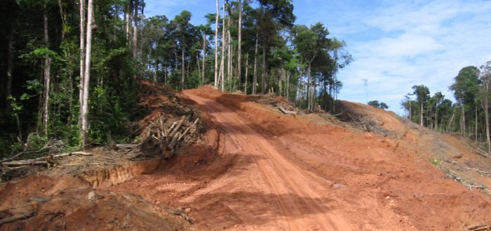
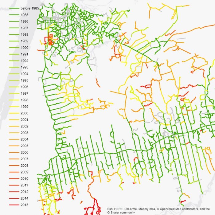
GIS is useful in many aspects of forest management, none more so than for monitoring forest loss. The revolution in remote sensing has given managers and observers a massively clearer picture of what is happening on the ground. The trend towards more timely data helps organisations respond in real time, and there is also a growing archive of historical data. gi Perspective were involved in a project to map historical forest roads, showing logging activities over time.
The task of monitoring land use changes and ecosystem health is made easier by bringing in the increasing amounts of open data (and methods). This allows organisations like Climate TRACE to provide independent assessments. There are widespread calls for greater transparency in supply chain information so that the real spatial impacts of individual companies and products on forest loss can be better evaluated. gi Perspective have been delighted to assist with such a spatial data infrastructure, for the European marine environment. The EMODnet Human activities web mapping portal provides access to extensive marine & maritime datasets, allowing public & commercial organisations to make smarter decisions.
The aim must be to use GI to allow science-based sustainable resource management. The scientific picture can be complex, as evidenced in publications such as the World Atlas of Desertification and the European Atlas of Forest Tree Species. GI science plays a role in difficult challenges such as modelling alternative scenarios, spatially targeting policies and interventions, and measuring their impact.
On-the-ground field data capture is also a standard part of forest management, such as in this project to locate and update tree information across London. That seems a long way from the tropical rainforests, although some London Boroughs have come out at the top of an England & Wales survey of tree cover.
Conclusion
Spatial information and GIS specialists are already central for forest management, and have an important role in efforts to tackle the climate crisis. The question remains: will the combination of humanity’s growing awareness and some sizeable high-level financial commitments be enough to urgently outweigh the fact that the Earth’s essential ecosystem services are still invisible in most economic (and many political) decisions.
Comments are closed here.