Using a web-based Geographical Information System or GIS can improve communication of your data inside your company. Most data within your organisation will be linked to a geographic location, whether it be client addresses, sales figures for geographic regions or statistics to target specific groups of people. Displaying, querying and analysing your data over online mapping allows you to effectively communicate your data across your organisation, and see patterns that you would not detect using databases and spread sheets alone.
Define boundaries with your data
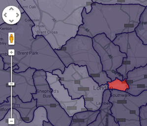
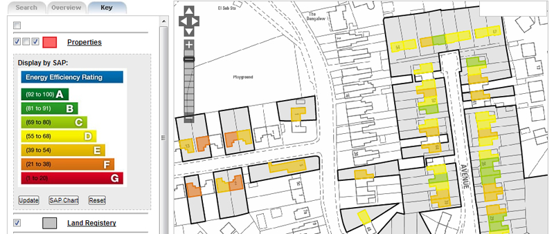
In a web-based GIS, address databases can be geocoded to find a location for each address that can be displayed over a map using a map pointer or marker. These markers can be colour-coded by a value specific to your data giving you an instant geographic picture of your data. Sales figures or population statistics can be linked to postcode, census or administrative boundaries. The boundaries can be coloured using values in your data to visualise your data geographically. Viewing and analysing your data over maps allows you to detect geographic clusters that maybe of interest, which may not have been possible when viewing only tabular data.
Information specific to your industry such as data related to properties, grounds maintenance, transport or utilities can be specially captured over detailed and accurate mapping or converted from old printed maps. Organising and managing such data spatially using a web-based GIS can improve communication of data within you company by:
- increasing participation in open discussion
- giving a voice to those who would not normally speak up
- aid the procurement process for services and maintenance in allowing geographic areas and distances to be accurately measured
- speed decision making and ultimately lead to better business decisions
Many web-based GIS technologies are now available. Google Maps allows you to easily geocode data and share maps publicly. Using the Goole Maps API, mapping websites can be customised to allow increased functionality and embed your map into your own website. Great Britain”s Ordnance Survey (OS) have their own API titled OS OpenSpace that uses more detailed OS mapping. These technologies however are limited, and are not necessarily suitable to sharing data just within your organisation. Google for instance, demand a significant annual fee if you prefer not to share your data and publically.
Happily there are other technologies available where GIS can improve communication, specifically within your company. Powerful server-based GIS software such as those available from the big GIS vendors are available for organisations to share, query, analyse and even edit data across the web. Such vendor-based software is off-the-shelf, and is easily scalable. As an alternative, Open Source web-based GIS software is available for programmers to exploit. Open Source software is developed by communities of enthusiasts and is freely available, removing the software cost from a web-based GIS implementation. Open Data can also be sourced allowing mapping and geographic data to be used within your internal web-based mapping solution free of charge.
Presentation and functionality of GIS
Concentrating your budget on development rather than software means that more customisation of presentation and functionality can become the focus of your GIS. Search, query and filtering facilities can be developed to enhance the user experience of your application. Security facilities such as log-in screens can be developed to allow your employees to use your web-based GIS from different locations, and allow filtered functionality or data for alternative user profiles.
Using a web-based GIS to improve communication and management of data within a company is a valuable and effective method to make the most of your data.
Comments are closed here.