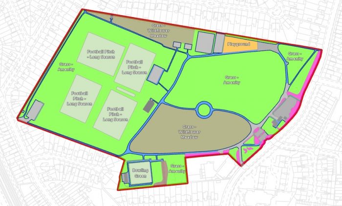
Grounds Maintenance plans or maps are used by councils, housing associations and their contractors to visualise and manage the assets requiring a maintenance regime. These assets can include Grass, Meadow, Shrubs, Hedges, Trees, Paths, Playgrounds, Multi-use Games Areas (MUGAs), Sports Pitches and Courts, Car Parks and Highway Verges.
From our experience in the creation or conversion of Grounds Maintenance digital maps – either from scratch or from outdated sources such as printed maps and PDFs – we can summarise the key benefits in digitally mapping Grounds Maintenance.
1. Cost-saving
Imagine being responsible for grass cutting, hedge trimming, weeding and highways verge maintenance for a whole local authority but not knowing the true geographic extents of these assets. Then imagine having to appoint a GM contractor on a fixed-price 4-year contract without such a bill of assets, their areas and lengths. Not knowing the true picture of the square meterage of sports fields, parks and amenities makes such GM tendering impossible to undertake with the necessary degree of accuracy and therefore costs. In short, a GM mapping exercise giving a true measurement of responsibilities can save an authority and/or contractor £millions in the long run.
2. Management information on the ground
The GM contractor to the housing association or local authority can benefit hugely from improved or even first-time Estate Plans, showing accurate grass cutting requirements and responsibility for the maintenance of hardstanding areas, also the associated tabular data showing total areas or linear metres. Because such assets are captured against real-world features found in Ordnance Survey base mapping, contractors can have a clear up-to-date picture of exactly what needs cutting or maintaining and of course what is outside of their scope of work. Such management information can be provided in the form of digital PDFs and Excel sheets and/or on GIS-compatible tablets linked to back-office scheduling regimes.
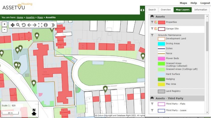
3. Integrate GM-improved data into your GIS
Because the digitising of such assets is done in the GIS environment, this produces a spatial dataset as well as a table of measurements. The resultant GIS Shapefiles can then be imported into an existing GIS system or map publishing software alongside other existing map-based datasets. This can then provide further derived benefits, for example allowing proximity analysis to green space per population for use in a council’s Green Space Strategy.
4. Environmental management benefits
As Local Authorities and Housing Associations seek to allocate a proportion of green space over to nature, biodiversity and re-wilding, an accurate set of GM maps can assist with this. A robust GM mapping exercise can split assets down into many discreet categories including a proportion of land reserved for conservation. Such detail and splitting out of areas can be digitised onto a Biodiversity Map from recent aerial imagery or indeed be manually added into the maps to meet landscape policy and decisions at a later date.
5. Rostering and scheduling
With all GM areas of responsibilities mapped across a region or district, such geographic locations can be queried spatially and decisions around scheduling made easier. For the contractor, grass cutting Team A can then be efficiently allocated to a certain asset round based on attainable distance and journey times between sites, all with the right equipment on board.
Finally, once the task of obtaining a current and true GM asset register is completed, updating the maps and/or GIS data for future changes and tweaks is easy and cost-efficient. These benefits can apply to all sizes and shapes of estate and are of real benefit to the organisations with responsibilities in this sector.
Please contact us to discuss how they can be applied to your organisation.
Comments are closed here.