The Environment Agency recently made freely available LIDAR data for over 70% of England. Airborne LIDAR (light detection and ranging) uses a laser light from an aeroplane to measure the height of the ground, buildings and other features. The output is a highly accurate 3D digital surface model (DSM) which can be utilised for many purposes. Mapping companies and GIS consultants can easily access the data and carry out 3D analysis for a wide range of purposes. Here, we explore some of the applications widely making use of LIDAR data.

Flood Risk
The reason why the Environment Agency release LIDAR data in the first place is to encourage businesses and local communities to undertake flood risk modelling. The resolution of the data ranges from 1 to 2 metres and the coverage tends to be focused on flood plains, coastal zones and urban areas. This means that accurate flood models can be created to asses flood risk down to individual properties. They can also aid the planning of flood defences and help avoid building in areas where flooding is likely to be a relatively common occurrence.
Siting of wireless communications
When you choose a location to install community wireless broadband or a mobile phone mast, you need to know exactly what areas will be able to receive your signal. Using a process called ‘View Shed’ analysis together with LIDAR data, an accurate signal coverage map can be created which takes into account the surrounding landscape, including hills, buildings and trees. Using this method, potential locations for wireless communications can be compared. Additionally, you can analyse what height your transmitter will have to be to reach the target coverage. A further process can be employed to list all the addresses that are likely to receive the new signal.
Assessing visual impact
Using the same method, you can analyse the visual impact of a new construction, such as buildings or wind turbines. By analysing LIDAR data, you can start to answer questions such as:
- How far away will the construction be visible?
- Which properties will be visually affected by the proposed structure?
- Will you be able to see the planned construction from a nearby major road, given the height of the adjacent trees?
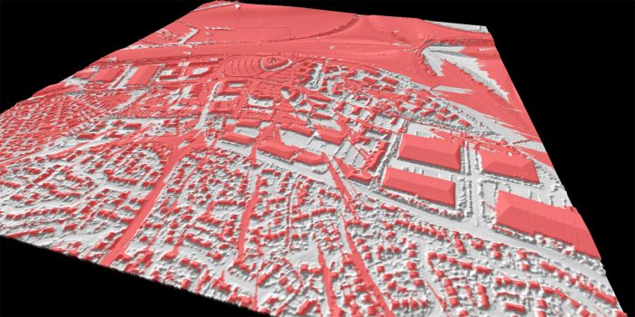
Visualising urban areas
Due to the detailed accuracy of LIDAR data, it is possible to extract a height for individual buildings. Combining this data with building footprints allows you to create 3D urban models with a neat three dimensional block for each building.
Archaeology
One of the areas to benefit the most from LIDAR data is archaeology. By experimenting with the lighting and display of LIDAR surface models in a 3D environment, it is possible to detect undiscovered subtle earthworks. Archaeologists are also experimenting with using LIDAR to penetrate gaps in woodland canopy to help create surface models of the ground below trees. In the last few years, studies using LIDAR data have led to the discovery of ‘lost’ roman roads across Britain and helped archaeologists gain a wider understanding of the landscape around Stonehenge.
Comments are closed here.