The web-based GIS portal, mapping marine and maritime data, has been renewed for a further two years
We are part of a consortium of companies (with Cogea, AND International, AZTI Tecnalia, CETMAR and Eurofish International Organisation) developing and maintaining a GIS-based services for European Commission Directorate-General for Maritime Affairs and Fisheries (DG MARE). The aim of the contract is to assemble fragmented marine and maritime mapping data on the extent and intensity of human activities, and make them available through a single web portal.
The contract, first signed in 2013, has been renewed until March 2023, with extensions available to March 2025.
Through the release of the EU Green Paper on a Future Maritime Policy for the European Union in 2006, poor access to marine and maritime data was confirmed to be a barrier to scientific understanding, a brake on the economy and a handicap to government decision-making. In 2008 the European Commission proposed to take steps towards a European Marine Observation and Data Network (EMODnet). “Human Activities” is the latest of the EMODnet lots.
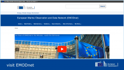
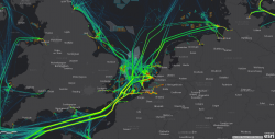
The EMODnet Human activities web portal, presents marine and maritime mapping data of a series of activities related to the sea. The initial website, launched in April 2014, has been extensively developed over recent years as more data is added. The mapping data is collated and harmonised by other consortium members from across the EU. GIS layers such as aggregate extraction, dredging, commercial shipping, pipelines and wind farms can be viewed and interrogated using the web portal.
During the renewed contract, the current web portal will be phased out and GIS data services will be integrated directly to a new central map viewer tying together data from all the EMODnet lots. The EMODnet Central Portal will move to a European Commission (Europa) web address: emodnet.ec.europa.eu which reflects the long-term commitment of DG MARE to EMODnet as a trustworthy and reliable operational service.
Our updated GIS services will serve GIS data to the Central Portal and direct to GIS desktop and app users through the use of OGC compliant Web Feature Services (WFS) and Web Map Services (WMS). We will be supporting the Consortium in extending the range and resolution of Human Activities data available as GIS services throughout the contract.
Comments are closed here.