Boston Mayflower Limited (Lincolnshire Housing Partnership since 2018), a Registered Housing Provider operating in the East Midlands, own and manage approximately 4,600 rented homes with a further 200 leasehold and shared ownership interests. In addition to these property assets, Boston Mayflower also manages 35 hectares of grassed open areas, footpaths and car parks.
Boston Mayflower wanted a cost-effective, web based GIS to improve communication of the data within the organisation. With outdated ownership boundaries marked on paper maps, they were seeking a solution to help manage communal areas and produce detailed, accurate information for tenants receiving service charges as well as improving efficiency of future procurement processes.
Detailed MasterMap vector mapping data was acquired through the Ordnance Survey. 500 original paper maps were scanned, and then the mapping information digitised into a GIS system and categorised. The resultant GIS data included properties, grounds maintenance areas and assets. Land registry areas were also acquired and incorporated into the spatial database. Detailed housing and tenant data, already held by the housing association in spread sheets, were linked to property areas.
To improve communication of the data, a web based GIS was developed using MapServer and OpenLayers. MapServer is an Open Source platform for publishing spatial data to the web via interactive mapping tools. OpenLayers is an Open Source JavaScript library allowing custom map functionality to be developed and integrated into web based GIS applications. Open Source software is developed by communities of enthusiasts and is freely available. Both MapServer and OpenLayers are supported by the Open Source Geospatial Foundation (OSGeo). The application developed for Boston Mayflower included customised functionality for address searching, data filtering, measuring, printing and the automatic colouring of properties by their energy efficiency rating.
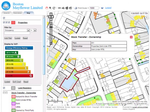
Funcionality including address searching, data filtering, measuring, printing and the automatic colouring of properties by energy efficiency rating
Although the housing association wanted to improve communication of their data using a web based GIS, it was important that sensitive data could be restricted. To allow this, user profiles were incorporated into the application to allow the filtering of data to specific users.
The application, is used to communicate data across the organisation. Front desk staff are able to quickly locate, view and query mapping relating to incoming queries. Management staff are able to analyse the data and make business decisions related to the procurement of services and the development of new housing.
Comments are closed here.