Major sporting events demand much more than athletic excellence. Behind the scenes, organisers face the immense challenge of coordinating infrastructure, operations, and commercial activities on a global stage. From planning transport routes and managing crowds to selling advertising space, efficiency and accuracy are essential.
One technology that has become increasingly central to these efforts is Geographic Information Systems (GIS).
When the Qatar Government’s Supreme Committee for Delivery & Legacy (SC) prepared for the FIFA World Cup Qatar 2022™, GIS played a pivotal role in managing and commercialising media assets across the country.

Photocreo Bednarek/stock.adobe.com
The Challenge: Managing Media Assets for a Global Audience
For an event of this magnitude, the SC needed to manage thousands of advertising assets—from banners to digital screens—spread across stadiums, airports, shopping malls, and other high-profile locations.
Not only did these assets need to be catalogued, but they also had to be marketed and sold to potential advertisers in a fast, reliable, and visually engaging way. Spreadsheets and static maps weren’t enough. The SC required a secure, centralised, and highly interactive mapping system.
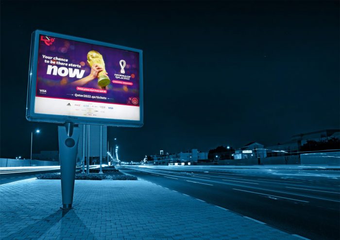
Image courtesy of Qatar Government Supreme Committee for Delivery & Legacy
The Solution: A GIS-Powered Media Mapping Application
gi Perspective worked with the SC to develop a media asset mapping application built on Esri’s ArcGIS Enterprise platform and ArcGIS Maps SDK for JavaScript.
The solution brought together geolocated data, imagery, and detailed information on media assets into a single browser-based tool. This allowed organisers and advertisers to:
- Log in securely with two-factor authentication.
- Visualise key infrastructure such as stadiums, airports, and shopping malls alongside available advertising locations.
- Filter media assets by type, site, price, or geographic area.
- View images and details for each asset, such as banners, MUPIs, and digital screens.
- Enable administrators to update prices, edit locations, and manage availability in real time.
By consolidating all this information into one GIS-driven platform, the SC could present opportunities clearly to advertisers while maintaining up-to-date control of their asset inventory.

LIGHTFIELD STUDIOS/stock.adobe.com
The Result: Streamlined Commercial Operations Before Kick-Off
The application was deployed in a secure hosted environment at SC’s headquarters in Doha a year before the tournament, enabling media sales to begin well in advance. Advertisers had an intuitive, interactive way to explore opportunities, while organisers gained full visibility of their assets.
The SC later praised the system, noting that the Media Mapping Application was a crucial part of the tournament’s operational and commercial success.
Beyond Qatar: GIS as a Game-Changer for Sporting Events
The World Cup example demonstrates how GIS can transform the way major sporting events are planned and managed. Whether it’s mapping media assets, planning transport routes, or managing crowd flows, GIS provides organisers with the spatial insight and interactive tools needed to deliver events at the highest level.
Comments are closed here.