Shuttle Radar Topography Mission (SRTM)
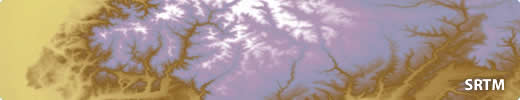
The Shuttle Radar Topography Mission (SRTM) was a research programme that obtained a Digital Elevation Model (DEM) of much of the Earth using the Space Shuttle. The data covers 56 degrees South to 60 degrees North. Initially released at a resolution of 3 arc-seconds, it is now available at the higher resolution of 1 arc-second and has been enhanced to reduce anomalies in the original data.
The data is in the public domain and is therefore can be downloaded for free. It can be used to create contours and hill shading of regional areas or used for small-scale GIS Analysis.
Experts in Geographic Information Systems
gi Perspective provides organisations of all shapes and sizes with geographic information and digital mapping solutions, utilising our staff's breadth of experience to exceed customer expectations.
See our GIS Services