British National Grid
The Ordnance Survey British National Grid is a grid referencing system for Great Britain. The grid references are used in conjunction with Ordnance Survey maps, but also with other maps and charts as well as some GPS-enabled mobile applications and GIS software.
How do I find a British National Grid reference?
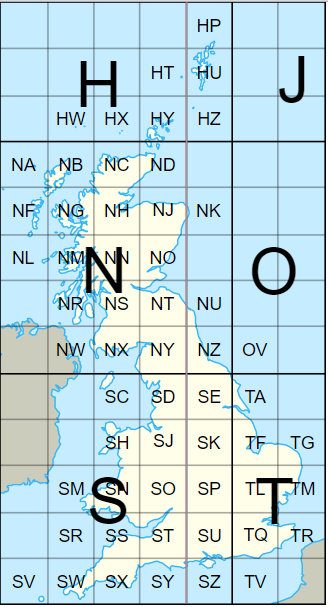
Most commonly, British National Grid references are determined using the blue grid on the Ordnance Survey Landranger and Explorer maps. Firstly, there is a two letter prefix to determine the 100km grid square.
The subsequent numbers can be structured as 4-figure, 6-figure or 8-figure coordinates, depending on the accuracy required. A 4-figure reference can be obtained using the blue grid, eastings first (across) followed by the northings (up). A 4-figure reference is only accurate to the 1km grid square.
4-figure Grid reference example: SP 43 14
For improved accuracy (e.g. for specifying the location of a field), then a third figure for each of the eastings and northings should be estimated by dividing the grid square up further into an imaginary 10 x 10 grid creating 100m grid squares. This is used to determine a 6-figure grid reference and is the most widely used reference.
6-figure Grid reference example: SP 435 143
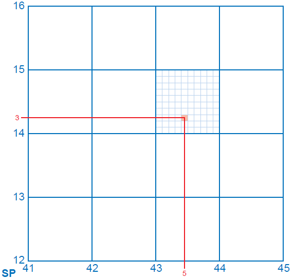
An eight figure grid reference would be accurate to 10 metres.
8-figure Grid reference example: SP 4357 1430
Examples can be found on the Ordnance Survey website.
Experts in Geographic Information Systems
gi Perspective provides organisations of all shapes and sizes with geographic information and digital mapping solutions, utilising our staff's breadth of experience to exceed customer expectations.
See our GIS Services